Coletazos del huracán Isaías traerán lluvias y vientos fuertes al área de Memphis este fin de semana
(LPL) – El área de Memphis se prepara para un fin de semana lluvioso debido al avance de los
(LPL) – El área de Memphis se prepara para un fin de semana lluvioso debido al avance de los remanentes del huracán Isaías, que se está fortaleciendo en el Golfo de México y se espera que llegue a la costa del Golfo antes de avanzar hacia el norte.
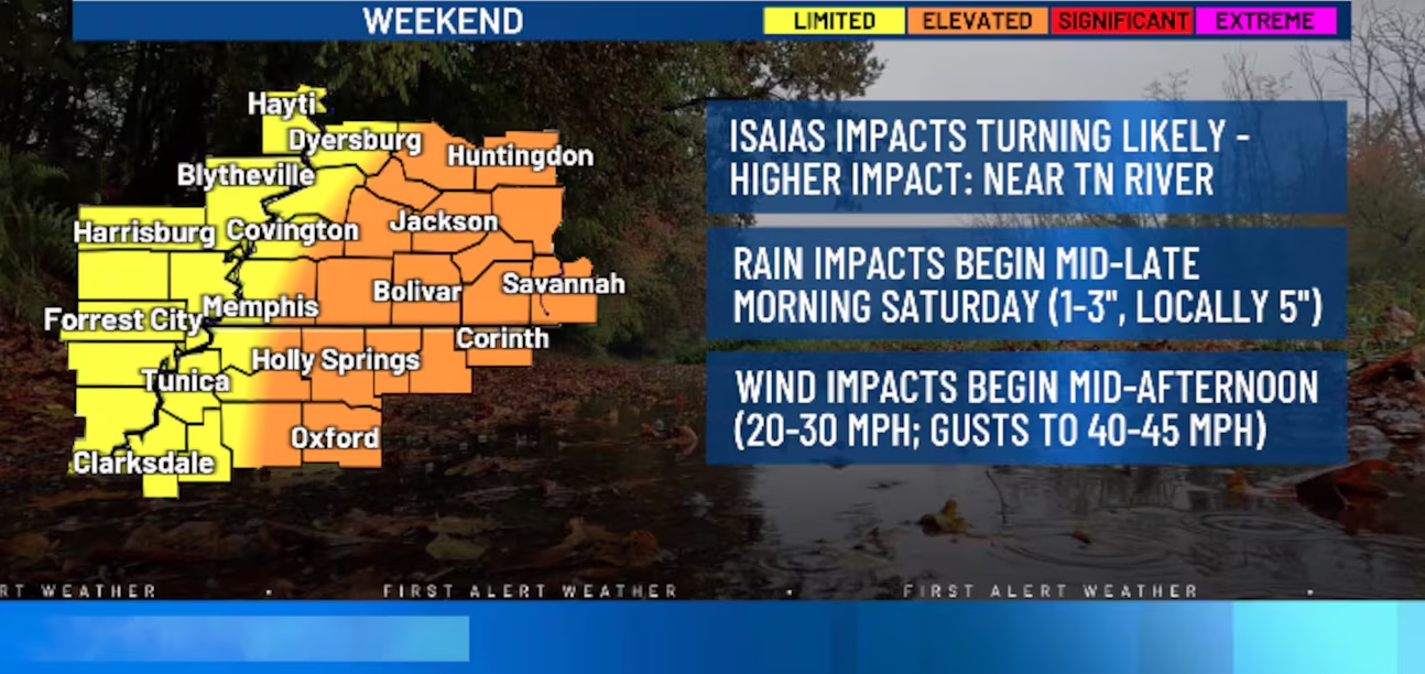
Después de varios días de temperaturas inusualmente altas, las condiciones comenzarán a cambiar el sábado. El Servicio Nacional de Meteorología en Memphis pronostica lluvias generalizadas y ráfagas de viento en el Medio-Sur, con los principales efectos entre el sábado y el domingo.
En Memphis y el resto del Medio-Sur, la lluvia comenzará a aumentar durante la mañana del sábado y podría intensificarse durante la tarde y la noche. Los pronósticos actuales estiman entre 1 y 3 pulgadas de lluvia en gran parte de la región, aunque algunas zonas podrían recibir cantidades superiores.
El Servicio Nacional de Meteorología también advierte de ráfagas de viento de hasta 35 millas por hora, mientras que algunas áreas podrían experimentar ráfagas más fuertes dependiendo de la trayectoria final del sistema. Las zonas cercanas al río Tennessee tienen una mayor posibilidad de recibir acumulaciones de lluvia.
Aunque Memphis no está en la trayectoria directa del huracán, sus remanentes podrían provocar períodos de lluvias intensas, calles inundadas y condiciones ventosas. También existe una posibilidad baja, pero no descartada, de que se desarrollen tornados aislados dependiendo de la trayectoria del sistema.
Las lluvias podrían continuar durante la mañana del domingo y disminuir gradualmente durante el día. Se espera que el tiempo mejore hacia el domingo por la tarde o noche.
El Centro Nacional de Huracanes indicó que Isaias se dirige hacia la costa norte del Golfo y se prevé que se fortalezca antes de tocar tierra. Sus efectos de lluvia se extenderán posteriormente hacia el sureste y el valle de Tennessee.
English:
Outer bands of Hurricane Isaias to bring rain and strong winds to the Memphis area this weekend
(LPL) – The Memphis area is bracing for a rainy weekend as the remnants of Hurricane Isaias approach; the storm is currently strengthening in the Gulf of Mexico and is expected to reach the Gulf Coast before moving northward.
After several days of unusually high temperatures, conditions will begin to change on Saturday. The National Weather Service in Memphis forecasts widespread rain and wind gusts across the Mid-South, with the primary impacts occurring between Saturday and Sunday.
In Memphis and the rest of the Mid-South, rainfall will begin to increase Saturday morning and could intensify during the afternoon and evening. Current forecasts estimate between 1 and 3 inches of rain across much of the region, though some areas could receive higher amounts.
The National Weather Service also warns of wind gusts up to 35 miles per hour, with some areas potentially experiencing stronger gusts depending on the system’s final path. Areas near the Tennessee River have a higher likelihood of significant rainfall accumulation.
Although Memphis is not in the hurricane’s direct path, its remnants could trigger periods of heavy rain, flooded streets, and windy conditions. There is also a low—though not impossible—chance of isolated tornadoes developing, depending on the system’s trajectory.
Rainfall could continue into Sunday morning before gradually tapering off throughout the day. Conditions are expected to improve by Sunday afternoon or evening.
The National Hurricane Center indicated that Isaias is heading toward the northern Gulf Coast and is expected to strengthen before making landfall. Its rainfall impacts will subsequently spread into the Southeast and the Tennessee Valley.