Aviso de Tormenta Eléctrica Severa vigente para Collierville, Oakland y Bolívar
Severe Thunderstorm Warning in effect for Collierville, Oakland and Bolivar (LPL/FOX13) – Las áreas de Collierville, Oakland y Bolivar,

Severe Thunderstorm Warning in effect for Collierville, Oakland and Bolivar
(LPL/FOX13) – Las áreas de Collierville, Oakland y Bolivar, y sus alrededores, en Tennessee, se encuentran bajo un Aviso de Tormenta Eléctrica Severa hasta las 10:30 a. m. del viernes, según el Servicio Meteorológico Nacional.
Es posible que se produzcan vientos de hasta 96 km/h y granizo del tamaño de una moneda de 25 centavos durante este período.
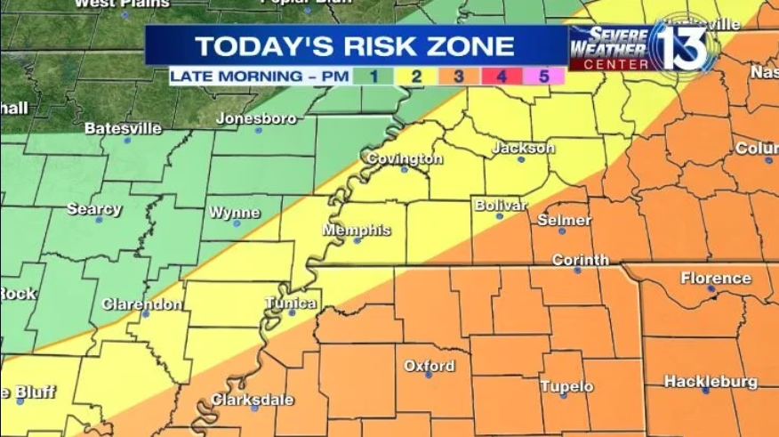
Algunas partes de la región centro-sur estarán bajo una amenaza de nivel 3 de 5 por clima severo a partir de la tarde de esta mañana. Las áreas afectadas incluyen el norte y noreste de Misisipi.
Mientras tanto, el área de Memphis permanecerá bajo una amenaza de nivel 2.
Asegúrese de llevar un paraguas.
El día comenzará con temperaturas templadas y nubes pasajeras.
Las lluvias aisladas de esta mañana aumentarán a partir de la tarde de esta mañana. Se espera que las temperaturas suban hasta los 21 °C en la región centro-sur.
English:
(LPL/FOX13) – The areas in and around Collierville, Oakland and Bolivar in Tennessee are under a Severe Thunderstorm Warning until 10:30 a.m. Friday, according to the National Weather Service.
Winds up to 60 mph and quarter-size hail are possible during this time.
Parts of the Mid-South will be under a Level 3 out of 5 threat for severe weather starting late this morning. The affected areas include northern and northeastern Mississippi.
Meanwhile, the Memphis area will remain at a Level 2 threat.
Make sure to have the umbrella.
It’s a mild start to the day with passing clouds.
Isolated showers this morning will pick up starting around late morning into the afternoon. Temperatures are expected to rise into the mid/upper 70s across the Mid-South.