
Tormentas peligrosas podrían azotar Memphis con fuertes vientos y granizo
(LPL) – Memphis y el Medio-Sur se prepara para un episodio de clima severo que podría afectar el área
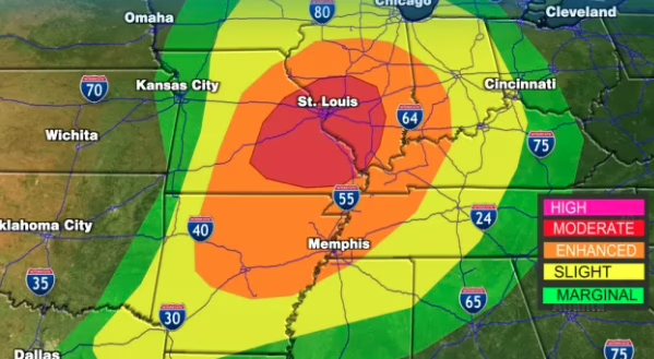
(LPL) – Memphis y el Medio-Sur se prepara para un episodio de clima severo que podría afectar el área desde la tarde del lunes hasta la madrugada del martes, con condiciones que incluyen tormentas fuertes, lluvias intensas, vientos dañinos y posible caída de granizo, además de un bajo riesgo de tornados aislados.
Durante la jornada del lunes se espera un ambiente cálido e inestable, con temperaturas cercanas a los 80 °F (aproximadamente 27 a 32 °C), lo que favorecerá el desarrollo de tormentas más organizadas hacia la tarde y la noche.
Los principales impactos se concentrarían entre la noche del lunes y las primeras horas del martes. Se anticipan ráfagas de viento que podrían superar los 58 mph (93 km/h), suficientes para causar daños a árboles, líneas eléctricas y estructuras débiles. También existe la posibilidad de granizo de tamaño moderado a grande en algunas de las tormentas más intensas.
En cuanto a las precipitaciones, se proyectan acumulados de 1 a 2 pulgadas (25 a 50 mm) de lluvia en varias zonas del Mid-South, lo que podría generar encharcamientos y problemas de drenaje en áreas urbanas.
El sistema de tormentas comenzaría a debilitarse gradualmente en la mañana del martes, aunque algunas lluvias residuales podrían persistir por varias horas.
Las autoridades meteorológicas recomiendan a la población mantenerse atenta a los cambios en el pronóstico, ya que la intensidad y el impacto de las tormentas podrían variar rápidamente conforme avance el sistema.
English:
Dangerous Storms Could Batter Memphis with Strong Winds and Hail
(LPL) – Memphis and the Mid-South are bracing for a severe weather event that could impact the area from Monday afternoon through the early hours of Tuesday. Conditions are expected to include strong storms, heavy rainfall, damaging winds, and possible hail, along with a low risk of isolated tornadoes.
A warm and unstable atmosphere is expected throughout the day on Monday, with temperatures hovering near 80°F (approximately 27–32°C); this environment will favor the development of more organized storms later in the afternoon and evening.
The primary impacts are expected to occur between Monday night and the early hours of Tuesday. Wind gusts exceeding 58 mph (93 km/h) are anticipated—strong enough to cause damage to trees, power lines, and vulnerable structures. There is also a possibility of moderate to large-sized hail within some of the most intense storms.
Regarding precipitation, rainfall accumulations of 1 to 2 inches (25 to 50 mm) are projected across various parts of the Mid-South, which could lead to localized flooding and drainage issues in urban areas.
The storm system is expected to begin gradually weakening on Tuesday morning, although some residual showers may persist for several hours.
Weather authorities advise the public to stay alert for updates to the forecast, as the intensity and impact of the storms could change rapidly as the system moves through the region.